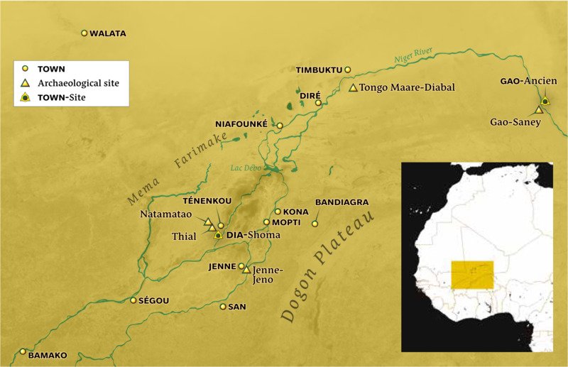
![Map of Niger River]() The immense and fertile floodplain known as the Inland Niger Delta covers more than 20,000 square kilometers. To its north, the Middle Niger region runs through the southern edge of the Sahara Desert before turning southeastward towards West Africa's forest region.
The immense and fertile floodplain known as the Inland Niger Delta covers more than 20,000 square kilometers. To its north, the Middle Niger region runs through the southern edge of the Sahara Desert before turning southeastward towards West Africa's forest region.
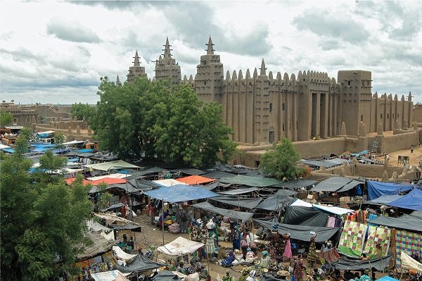
![The great mosque of Jenne]() The great mosque of Jenne and the Monday great market, August 2013. Photograph by Hamdia Traore
The great mosque of Jenne and the Monday great market, August 2013. Photograph by Hamdia Traore
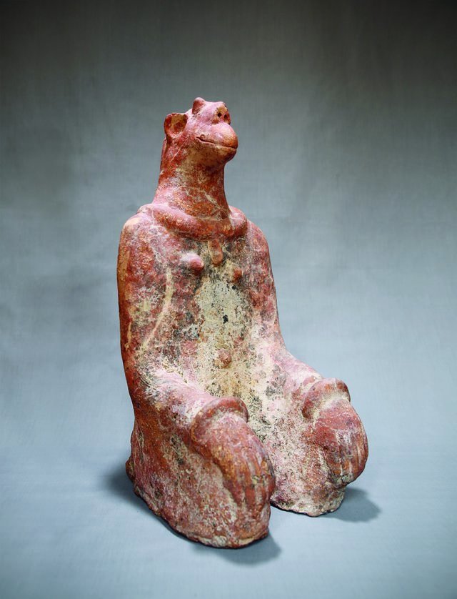
![Kneeling Figure. Terracotta, 46 x 22.4 x 21.5 cm.]() Kneeling Figure, Natamatao, Mopti region, Mali, 12th/14th century. Terracotta, 46 x 22.4 x 21.5 cm. Musée national du Mali, Bamako, 90.25.10. Photograph by Seydou Camara
Kneeling Figure, Natamatao, Mopti region, Mali, 12th/14th century. Terracotta, 46 x 22.4 x 21.5 cm. Musée national du Mali, Bamako, 90.25.10. Photograph by Seydou Camara
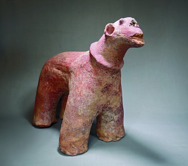
![Horse. Terracotta, 37.7 x 23.5 x 45 cm.]() Horse, Natamatao, Mopti region, Mali, 12th/14th century. Terracotta, 37.7 x 23.5 x 45 cm. Musée national du Mali, Bamako, 2002.17.16. Photograph by Seydou Camara
Horse, Natamatao, Mopti region, Mali, 12th/14th century. Terracotta, 37.7 x 23.5 x 45 cm. Musée national du Mali, Bamako, 2002.17.16. Photograph by Seydou Camara
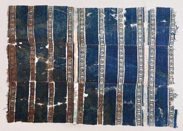
![Fragment of a woven blanket. Cotton and wool textile in weft-faced plain weave, 60 x 84 cm.]() Fragment of a woven blanket, Tellem, Mali, 15th century. Cotton and wool textile in weft-faced plain weave, 60 x 84 cm. Musée national du Mali, Bamako, Y-74-22. Photograph by Seydou Camara
Fragment of a woven blanket, Tellem, Mali, 15th century. Cotton and wool textile in weft-faced plain weave, 60 x 84 cm. Musée national du Mali, Bamako, Y-74-22. Photograph by Seydou Camara
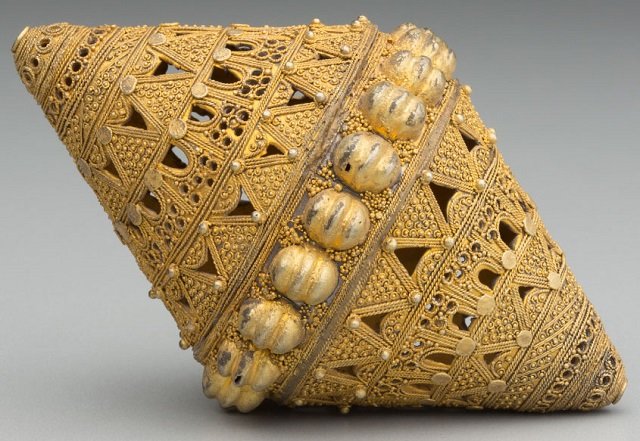
![Biconical bead]() Biconical bead, Fulani, Senegal, 19th/20th century. Gilded silver, 10.2 x 6 cm. Detroit Institute of Arts, Founders Society Purchase, Eleanor Clay Ford Fund for African Art, 77.10. Photograph courtesy of the Detroit Institute of Arts
Biconical bead, Fulani, Senegal, 19th/20th century. Gilded silver, 10.2 x 6 cm. Detroit Institute of Arts, Founders Society Purchase, Eleanor Clay Ford Fund for African Art, 77.10. Photograph courtesy of the Detroit Institute of Arts
 The immense and fertile floodplain known as the Inland Niger Delta covers more than 20,000 square kilometers. To its north, the Middle Niger region runs through the southern edge of the Sahara Desert before turning southeastward towards West Africa's forest region.
 The great mosque of Jenne and the Monday great market, August 2013. Photograph by Hamdia Traore
 Kneeling Figure, Natamatao, Mopti region, Mali, 12th/14th century. Terracotta, 46 x 22.4 x 21.5 cm. Musée national du Mali, Bamako, 90.25.10. Photograph by Seydou Camara
 Horse, Natamatao, Mopti region, Mali, 12th/14th century. Terracotta, 37.7 x 23.5 x 45 cm. Musée national du Mali, Bamako, 2002.17.16. Photograph by Seydou Camara
 Fragment of a woven blanket, Tellem, Mali, 15th century. Cotton and wool textile in weft-faced plain weave, 60 x 84 cm. Musée national du Mali, Bamako, Y-74-22. Photograph by Seydou Camara
 Biconical bead, Fulani, Senegal, 19th/20th century. Gilded silver, 10.2 x 6 cm. Detroit Institute of Arts, Founders Society Purchase, Eleanor Clay Ford Fund for African Art, 77.10. Photograph courtesy of the Detroit Institute of Arts